
When is Storm Jocelyn due to hit the UK?
23 January 2024, 13:23


Where will Storm Jocelyn hit and when? Everything you need to know about weather warnings across Northern Ireland, Wales, Manchester and the rest of the UK.
Listen to this article
Loading audio...
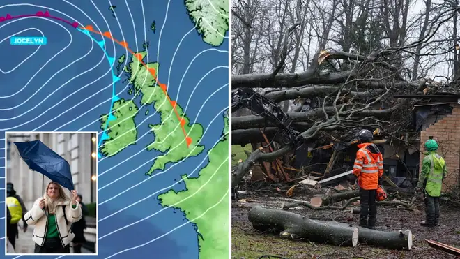
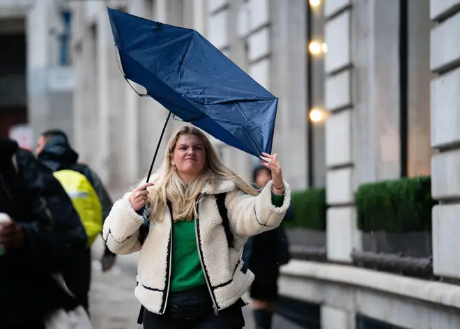
Storm Jocelyn will arrive in the UK this week, just days after Storm Isha caused chaos with high winds of up to 99mph.
The latest weather system has caused a number of weather warnings to be put in place by the Met Office, with Northern Ireland, Wales and Scotland expected to see the worst of the rain and wind.
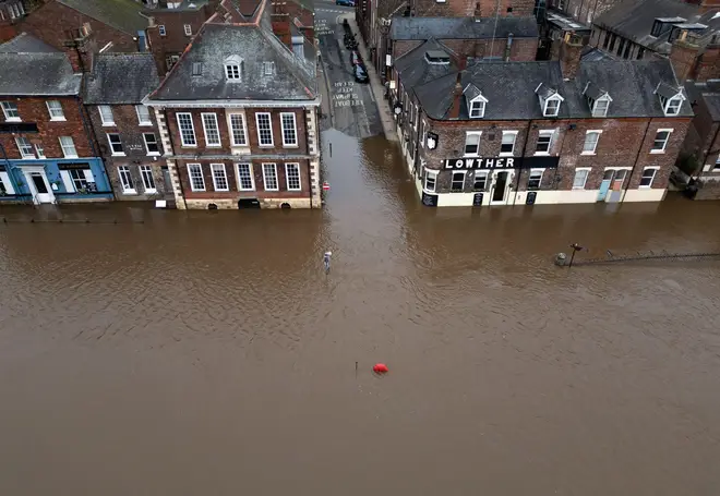
There are, however, weather warnings in place for rest of the UK as Storm Jocelyn is expected to causes flooding, power cuts and travel disruptions.
Here's everything you need to know about Storm Jocelyn including when it will hit your region, the meaning behind the name and weather warnings.
Where is Storm Jocelyn going to hit?
Storm Jocelyn will hit most of the UK this week, with the worst conditions arriving on Tuesday evening and into Wednesday.
Northern Ireland, North Scotland, Wales and the Midlands are expected to see the heaviest rain and strongest winds, with multiple weather warnings in place.
There is a jet stream pushing the large-scale, low-pressure weather system (named Storm Jocelyn by the Met Office this week) which will bring strong winds and heavy rain to most of the UK.
Met Office Chief Meteorologist, Steve Willington, said: “Although this system will be a step down relative to Storm Isha, with the damage and clean up still underway, we could potentially see more impacts from Storm Jocelyn.
“Outbreaks of heavy rain on Tuesday could bring rainfall accumulations of 15 to 20 mm quite widely with 40 to 50 mm over higher ground in southwest Scotland, the Scottish Highlands and parts of northwest England. Wind gusts are expected to reach 55 to 65 mph across northwestern Scotland while there is potential for winds to gust to 75 to 80 mph in a few places, in particular exposed parts of the Western Isles and coastal northwest Scotland early on Wednesday morning.”
Why is it called Storm Jocelyn?
Storm Jocelyn was named by the Met Office on Monday, 22nd January following the impact on the UK of Storm Isha over the weekend.
The Met Office name their storms in alphabetical order, and with this weather system being the tenth storm of the winter season it has been named with the letter J.
It is believed regions and organisations such as the Met Office have already decided names for their storms for each letter of the alphabet which are put in place to help meteorologists and the public communicate over the weather system.
There is no correlation between the storm name meanings about the weather they will bring, but if you were wondering the name Jocelyn is from Old German origin, meaning "member of the Gauts tribe." It also has Hebrew roots, meaning "happy" and "joyful".
What are the UK weather warnings for Storm Jocelyn?
These are the weather warnings in place for the UK as Storm Jocelyn arrives:
Tuesday 23rd January
Wales - Yellow weather warning for rain
- Bus and train services probably affected with journey times taking longer
- Spray and flooding on roads probably making journey times longer
- Flooding of a few homes and businesses is likely
Northern Ireland, England Midlands, North England, Wales and Scotland - Yellow weather warning for rain
- Some bus and train services affected, with some journeys taking longer
- Some delays to road, rail, air and ferry transport expected
- Coastal routes, sea fronts and coastal communities will be affected by spray and/or large waves
- Delays for high-sided vehicles on exposed routes and bridges
North West England - Yellow weather warning for rain
- Bus and train services probably affected with journey times taking longer
- Spray and flooding on roads probably making journey times longer
- Flooding of a few homes and businesses is likely
South West Scotland - Yellow weather warning for rain and wind
- Bus and train services probably affected with journey times taking longer
- Spray and flooding on roads probably making journey times longer
- Some roads and bridges may close, often blocked by fallen trees and other debris.
- Some damage to buildings, such as tiles blown from roofs, could happen
- Power cuts may occur, with the potential to affect other services, such as mobile phone coverage
- Any remaining recovery efforts off the back of Storm Isha are likely to be hampered
- Road, rail, air and ferry services may be affected, with longer journey times and cancellations possible
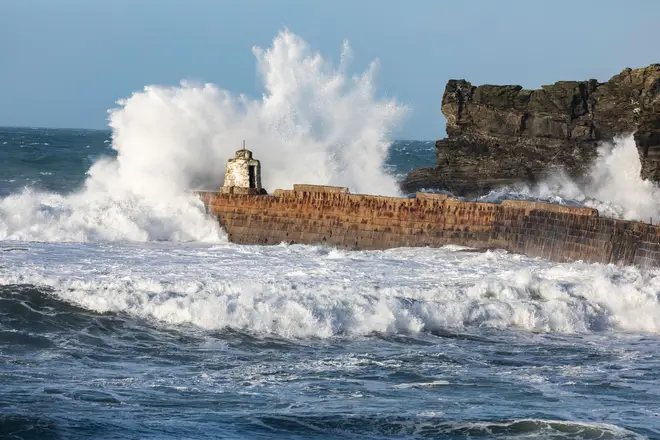
- There is a chance of Injuries and danger to life from large waves and beach material being thrown onto sea fronts, coastal roads and properties
North West & East Scotland - Amber weather warning for wind
- There is a good chance that power cuts may occur, with the potential to affect other services, such as mobile phone coverage
- Probably some damage to buildings, such as tiles blown from roofs
- Longer journey times and cancellations likely, as road, rail, air and ferry services may be affected
- Some roads and bridges likely to close
- Injuries and danger to life is likely from large waves and beach material being thrown onto coastal roads, sea fronts and properties
Wednesday 24th January
South Wales, Midlands, West England - Yellow weather warning for wind
- Some bus and train services affected, with some journeys taking longer
- Some delays to road, rail, air and ferry transport expected
- Coastal routes, sea fronts and coastal communities will be affected by spray and/or large waves
- Delays for high-sided vehicles on exposed routes and bridges
North Wales, Northern Ireland & Scotland - Yellow weather warning for wind
- Some roads and bridges may close, often blocked by fallen trees and other debris.
- Some damage to buildings, such as tiles blown from roofs, could happen
- Power cuts may occur, with the potential to affect other services, such as mobile phone coverage
- Any remaining recovery efforts off the back of Storm Isha are likely to be hampered.
- Road, rail, air and ferry services may be affected, with longer journey times and cancellations possible
- There is a chance of Injuries and danger to life from large waves and beach material being thrown onto sea fronts, coastal roads and properties
West, North and East of Scotland - Amber weather warning for wind
- There is a good chance that power cuts may occur, with the potential to affect other services, such as mobile phone coverage
- Probably some damage to buildings, such as tiles blown from roofs
- Longer journey times and cancellations likely, as road, rail, air and ferry services may be affected
- Some roads and bridges likely to close
- Injuries and danger to life is likely from large waves and beach material being thrown onto coastal roads, sea fronts and properties
Read more:
- Storm Isha brings down Dark Hedges trees made famous in Game of Thrones
- UK weather: Temperatures set to change - as new Met Office warnings issued for wind and rain
- Storm Jocelyn hits UK as new weather warning issued for rain


